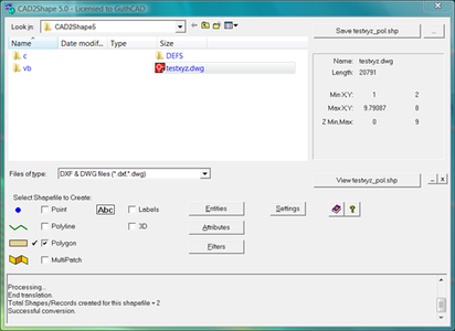
CAD2Shape 7.0 converts AutoCAD DXF/DWG drawing files to ESRI shapefile format files (ArcView, ArcGIS, ArcMap etc.)
Features
- Stand-alone CAD to Shapefile conversion.
- Translates all AutoCAD DXF and DWG versions up to and including AutoCAD 2014 New
- Optional translation to 2D or 3D shapefiles.
- Attach Z value as 'Elevation' data.
- Text to 'Labels Theme'.
- Text to exploded polyline option. - allows direct translation of CAD Text to visible text in ArcGIS/ArcMap/ArcView. The resultant text and placement will be visually identical to that in the originating CAD drawing.
- Attributes translation.
- Translate holes / islands /donuts from originating CAD drawing to Polygon shapefile. see picture
- Extended Entity Data (Xdata) translation.
- Translate 3D surfaces to MultiPatch shapefile types.
- Option to output to raw data file: e.g. CAD to XYZ, CAD to CSV, CAD to BLN New(Surfer Blanking file format).
- MPolygon support. New
- Dimensions/Leader/Tolerance support. New
- Additional XDATA types. New
- Length attribute for polylines. New
- Filter by Layer, Area, Color, Entity.
- Data suitable for import to Google Earth Pro
OS: Win 2003/2008/2012/Citrix/XP/XP64/Vista/Vist64/Win7/win7x64/Win8/Win8x64
http://www.guthcad.com/cad2shape.htm
Download File Size:11.07 MB