x64
Working with raster imagery doesn't have to be complicated. Geographic Imager® enhances Adobe Photoshop to make working with spatial imagery quick and efficient. It adds tools to import, edit, manipulate and export geospatial images such as aerial and satellite imagery. Enjoy the use of native Adobe Photoshop functions such as transparencies, filters, pixel editing, and image adjustments like brightness, contrast, and curve controls while maintaining spatial referencing.
Geographic Imager supports GeoTIFF in Adobe Photoshop and other industry standard raster formats. Mosaic and tile images, change projections, transform, rectify and georeference images based on ground control points. Batch-process your imagery using Geographic Imager and Adobe Photoshop scripting capabilities. Geographic Imager is a great companion to MAPublisher for Adobe Illustrator—prepare images in Geographic Imager and use them in MAPublisher.
Feature Highlights
Georeference images easily by adding ground control points. Manually add control points, import or export points from a text file, and view accuracy and errors. Use the Quick Georeference option to make georeferencing even easier. Multiple transformation types are supported.
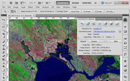
Geographic Imager Panel
Redesigned for Adobe Photoshop CS5, the Geographic Imager® panel provides access to all the tools and functions quickly and easily. All spatial information related to a GeoTIFF, DEM, ECW, MrSID or other supported image including the co-ordinate system, world location of the corners and pixel size are displayed along with buttons to access the various Geographic Imager functions. More time is left to edit geospatial data rather than searching for tools.
Retain Spatial Properties
Geographic Imager allows the use of Adobe Photoshop native functionality without destroying the spatial properties of a GeoTIFF, DEM, ECW, MrSID or other spatial image. Easily manipulate and adjust the visual elements such as colour values and levels, histograms, hues and sharpness. Spatial properties of the image are automatically updated and retained even after performing crop, rotate or geospatial adjustments. This is important in industries such as photogrammetry and remote sensing where it is necessary for analysis.
Import and Export Spatial Imagery
improved . Import and manage georeferenced imagery in Adobe Photoshop such as GeoTIFF, NITF, PCI and other compatible raster data formats, including support for CIR, RGBI and other multispectral and multichannel data. Advanced Import allows you to crop images during the import process (before they are opened), making it a great way to crop large images.
Geospatial PDF support
Create Adobe Acrobat PDF files containing coordinate systems from Geographic Imager image or import and modify existing Geospatial PDF documents. Easily share or publish them online. Find locations, measure distances, perimeters and areas, add locations markers and customize export settings. Take the geospatial PDF maps on the go using the PDF Maps iOS app.
Import Elevation Data
Import DEM formats such as ArcInfo ASCII Grid, ArcInfo Binary Grid, USGS DEM ASCII/CDED, Military Elevation Data/DTED and SRTM. Assign a DEM Schema during import for easier rendering. Overlay aerial photography to create custom looking images.
Terrain Shader
Create shaded relief maps from DEM data in Adobe Photoshop quickly and easily using the Terrain Shader feature. Control intensity and lighting source. Define elevation intervals for custom colour ramps.
Georeference Imagery
Import or add ground control points for accurate georeferencing of aerial photography or satellite imagery with multiple transformation types supported. Assess residual errors to improve geoferencing and save control point data as reference files. Quick Georeference by a single tie point, two tie points, or from other documents.
Transform
Extensive support for thousands of geographic and projected coordinate systems with the ability to save custom definitions for future use. Re-center images using a custom central meridian and modify pixel resolution.
Mosaic
Mosaic raster images to create a seamless image. Retain images as separate layers or flatten to create one image. Now supports image transformation during Mosaic, making it easier to get the images the way you want. Also, now create seamless mosaics of images with different coordinate systems, pixel sizes, channels and colour modes.
Tile
Tile raster data into multiple images by tile size or count and automatically saves tiles using sequential naming into any supported spatial image format. Great for turning large satellite images into smaller tiles and serving them online.
GeoCrop
The GeoCrop tool allows image cropping based on a combination of pixels or geographic coordinates (geodetic and projected). Easily define coordinates or draw a crop area to see a preview. Advanced Import allows you to crop images during import, making it a great way to crop large images without the need to open them first.
Merge and Split Channels
Adobe Photoshop Merge and Split Channels are now supported. Useful for remote sensing, create false- and true-colour images and retain all georeferencing.
Automate Tasks
Create scripts and actions of Geographic Imager and Adobe Photoshop tools to automate repetitive tasks. All Geographic Imager tools are compatible with automation.
System Requirements
Windows
-Adobe Photoshop CS6 / CC 2015 / CC 2015.5 / CC 2017 (all including 64-bit)
-2 GHz or faster Intel Pentium 4 processor (Intel Core 2 Duo or better recommended)
-Windows 7 or higher (compatible with 64-bit versions)
-4 GB RAM (8 GB or higher recommended)
-300 MB of available hard-disk space for installation
-DVD-ROM drive (for DVD version)
-1024x768 display (1280x800 recommended)
Mac
-Adobe Photoshop CS6 / CC 2015 / CC 2015.5 / CC 2017
-Multicore Intel processor
-Mac OS X 10.10 or higher
-4 GB of RAM (8 GB or higher recommended)
-300 MB of available hard-disk space for installation
-DVD-ROM drive (for DVD version)
-1024x768 display (1280x800 recommended)
http://www.avenza.com/geographic-imager
Download File Size:249 MB